Visiting Camp Coxcomb
of the
World War II Desert Training Center
in California
(Also Camp Young)
This page was begun May 12, 2006
Bookmark this page as http://www.7thArmdDiv.org/coxcomb.htm
Last updated: February 5, 2018 - What's New?
Stuck in someone's frames? Click
here to break out.
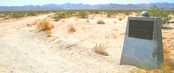
Original Camp Coxcomb Monument
Photo by Wesley Johnston - May 12, 2006
|

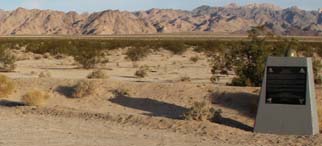
Re-dedicated Camp Coxcomb Monument
Photo by Wesley Johnston - April 15, 2014
Click on image for full size
|
Re-dedicated Camp Coxcomb Monument
Photo by Wesley Johnston - April 15, 2014
|
Welcome to Wesley Johnston's web page dedicated to helping you find Camp Coxcomb (or Camp Young) a lot more easily than I did.
Here are the contents of this page:
- Camp Coxcomb
- Camp Young
- Desert Training Center
|
NOTE: I included Camp Young only because it was on my route. As far as I know, Camp Young had no relevance to 7th Armored Division, other than that it was the Headquarters of the Desert Training Center. However, Camp Bouse, one of the other of the 12 camps of the Desert Training, was relevant, though no one knew it at the time. The 9th Armored Group trained at Camp Bouse, which is a good distance further east from Camp Coxcomb. In January 1945, most of the staff of the Headquarters of the 9th Armored Group was transferred as a group to expand the Headquaters of 7th Armored Division's Combat Command "R".
External Links
Visiting Camp Coxcomb
Cautions: This is not territory that most people are familiar with. It is isolated desert, with no one around for 15 miles in any direction. So here are a few cautions about visiting the area.
- Heat
- You: Take plenty of drinking water: My thirst and sweating were such that I drank about a half liter of water each hour. Wear clothing that will protect your skin from the sun: I even wore a towel under my cap to cover the back of my neck. Use sun block on exposed skin. Wear shoes that are appropriate for walking in hot sand.
- Your Car: Fill you gas tank before heading out into the desert. The nearest gas is 15 miles south at Desert Center, CA, along Interstate 10. Make sure your car is in good working condition, with good tires. Using your air conditioner on the climb can cause your car to overheat; so try to get used to driving without the air conditioner. Stay on solid roads unless you have 4-wheel drive: the last thing you want is to have your car stuck in the sand in a place where cell phones do not work and no one is around for 15 miles and the temperature is 120 in the shade -- except that there is no shade.
- Here is an account of one of E/48 AIR's (which later became B/23 AIB) experiences on 5 May 1943:
"Through Texas, Arizona and New Mexico we traveled and landed on the Mohave Desert at Camp Cox Comb, Calif. surrounded by Cox Comb, Palen and Iron Mountain and not the beautiful orange groves and lovely women we had always thought of when the Golden State was mentioned. Our experiences were great but very hard on the desert. I shall never forget the fifteen miles march across Palen Pass that the infantry had to make on May fifth, nor shall I forget how bad, physically, our men looked as they staggered in for food and a drink of water that evening. Some of the men had chewed gum to prevent their mouth from becoming so dry, but even this didn�t keep their mouth moist and the gum had to be pulled out in strings. Several passed out and had to be carried in. These incidents were not a matter of not being a man, but a matter of overtaxing good men�s strength."
-- by Eugene Jones in "Buzzings of Company 'B'"
- Isolation
Camp Coxcomb is 15 miles from even the isolated service station at Desert Center, CA. The area does now have cell phone service. But just to be safe, as you drive, keep track of where the call boxes are along the road and keep track of the mileage markers, so that you know where you are at all times and where the nearest call box is.
- Hazards of Nature
Be careful of snakes and cacti. Watch where you are about to step or are about to place your hand: look before you step, so that you do not expose yourself to a snake bite. Here is an account of one of E/48 AIR's (which later became B/23 AIB) experiences:
"Those three day problem were killers with cactuses for pillows and side winder rattlers or scorpions for bed fellows ..."
-- by Eugene Jones in "Buzzings of Company 'B'"
Getting There
I have to thank the folks at the Patton Museum at Chiriaco Summit. Even with verbal directions, I still had to make two trips out there, since the only thing visible from the road is the monument -- and it is easy to miss that if you are not looking for it.
From the Desert Center exit off of Interstate 10, take California Highway 177 north. There are white markers every mile, numbering from 0 at the Interstate. There are also frequent roadside emergency phones -- keep a watch on these so that you always know where the last one you passed was at, in case you get into trouble.
As you go north on 177, there are telephone poles on the left side of the road. Watch for the place where the telephone poles end, which is just past the 15 mile marker. The telephone poles actually turn left there. Continue on to the 17 mile marker, which is where the Camp Coxcomb monument is on the left (west) side of the road. The monument is at the junction with the sand road that leads west, which was the main road into the camp. (See map below.) Do NOT use that road unless you have 4-wheel drive. It has deep loose sand, and you can easily get stuck there in a 2-wheel drive vehicle.
If you go back to the road that heads west from the 15-mile marker, this road was passable with a 2-wheel drive in May 2006. There are a few sites to the south (left as you drive in) of that dirt road. South of where the road meets the Los Angeles aqueduct, I found two concrete floor slabs of buildings. Further back toward 177 from the aqueduct, there is an undrivable road that goes off to the south (left side as you drive in, right side as you drive out), and if you follow it on foot, you will find what appear to be concrete piers and cables, possibly for some sort of small bridge.
There may be more there. The lady at the Patton Museum (at Chiriaco Summit, CA -- about 35 miles away) told me that where the mountains (the Coxcomb Mountains -- which are part of Joshua Tree National Park) comes close to Hwy 177 there are bunkers, but I did not see those. She also said that there is a chapel still out there somewhere, but I did not find that either.
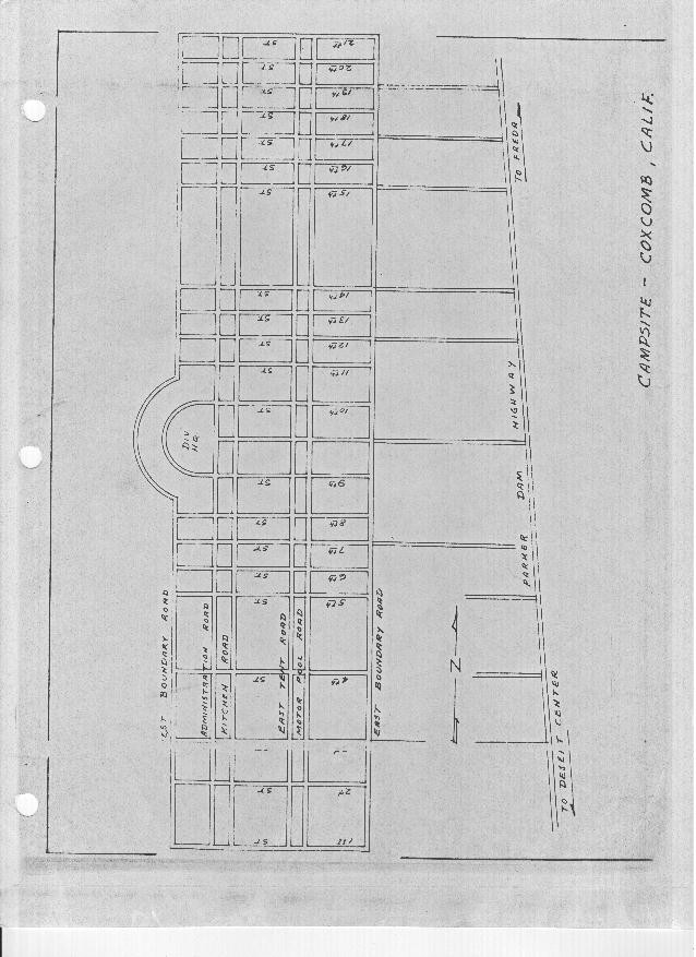
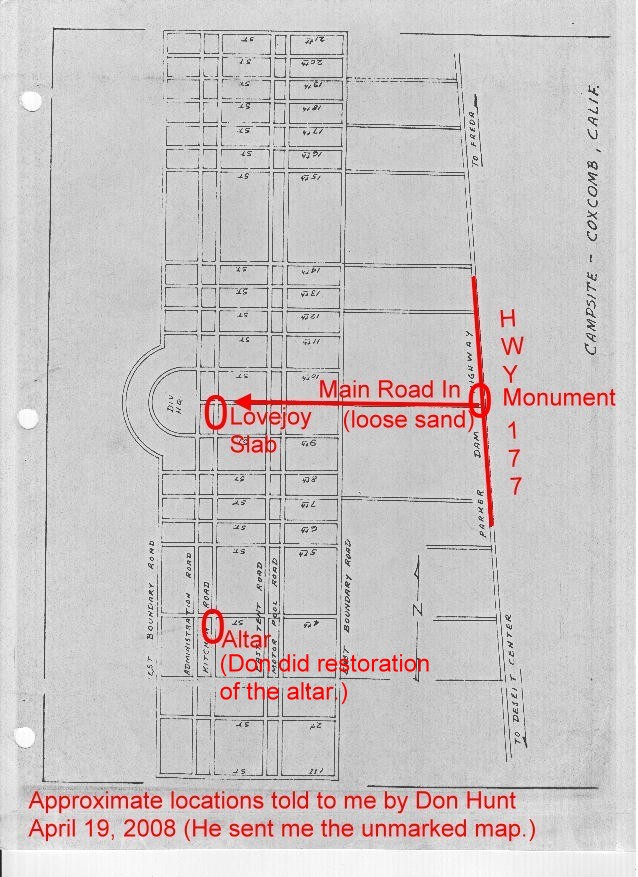
Camp Coxcomb Layout
You will have to be imaginative to see the layout now, but this map should help.
Click on either version of the map to see the image full size.
|
Here are three GPS readings I took in March 2011 with the GPS Essentials app on my cell phone.
- The first is a circular depression which may be a filled in latrine. It was just east of a road at 33�54.273'N 115�16.558'W. In looking on Google Earth, this seems to be an accurate reading, since it is correct in relation to the side of the road.
- The second was a bit north of the first but on the other side of the road � two ocotillo plants that were in blossom, so that I took many pictures, especially of the blossoms with the sky in the background. The reading that I wrote down is clearly wrong. It was hard to see the cell phone screen, due to the bright sunlight. I wrote down 33�56.505'N 115�16.642'W. In trying things out on Google Earth, my best guess, in relation to the circular depression, is that the correct reading should have been about 33�54.305'N 115�16.552'W.
- The chapel gave a reading of 33�53.702'N 115�16.810'W which seems about right. It is off the west side of the same road as the other two readings.
|
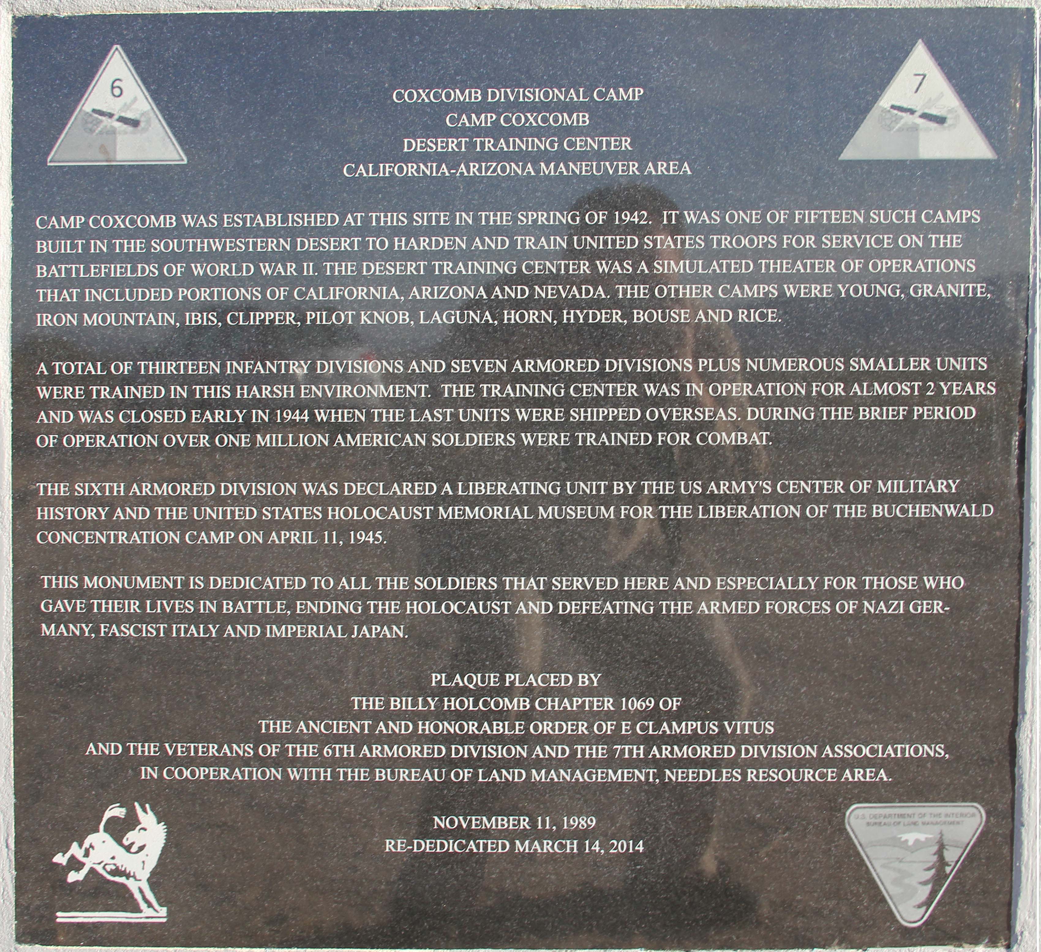
Text of the Camp Coxcomb Monument
Note that the upper left has the patch of the 6th Armored Division and the upper right that of the 7th Armored Division.
In 2013, someone stole the original bronze plaque. So the text of both plaques is given here.
Original Marker Text
Coxcomb Divisional Camp
Camp Coxcomb
Desert Training Center
California-Arizona Maneuver Area
Camp Coxcomb was established at this site in the Spring of 1942. It was one of twelve such camps built in the southwestern deserts to harden and train United States troops for service on the battlefields of World War II. The Desert Training Center was a simulated theater of operations that included portions of California, Arizona and Nevada. The other camps were Young, Granite, Iron Mountain, Ibis, Clipper, Pilot Knob, Laguna, Horn, Hyder, Bouse and Rice.
A total of 13 infantry divisions and 7 armored division plus numerous smaller units were trained in this harsh environment. The Training Center was in operation for almost 2 years and was closed early in 1944 when the last units were shipped overseas. During the brief period of operation over one million American soldiers were trained for combat.
This monument is dedicated to all the soldiers that served here, and especially for those who gave their lives in battle, ending the Holocaust & defeating the armed forces of Nazi Germany, Fascist Italy and Imperial Japan.
Plaque placed by the Billy Holcomb Chapter of the Ancient & Honorable Order of E Clampus Vitus, the Veterans of the 6th Armored Division, the 7th Armored Armored Division Association and in cooperation with the Bureau of Land Management, Needles Resource Area.
November 11, 1989
|
Re-Dedicated Marker Text
Coxcomb Divisional Camp
Camp Coxcomb
Desert Training Center
California-Arizona Maneuver Area
Camp Coxcomb was established at this site in the Spring of 1942. It was one of fifteen such camps built in the southwestern desert to harden and train United States troops for service on the battlefields of World War II. The Desert Training Center was a simulated theater of operations that included portions of California, Arizona and Nevada. The other camps were Young, Granite, Iron Mountain, Ibis, Clipper, Pilot Knob, Laguna, Horn, Hyder, Bouse and Rice.
A total of thirteen infantry divisions and seven armored divisions plus numerous smaller units were trained in this harsh environment. The Training Center was in operation for almost 2 years and was closed early in 1944 when the last units were shipped overseas. During the brief period of operation over one million American soldiers were trained for combat.
The Sixth Armored Division was declared a liberating unit by the US Army's Center of Military History and the United States Holocaust Memorial Museum for the liberation of the Buchenwald Concentration Camp on April 11, 1945.
This monument is dedicated to all the soldiers that served here, and especially for those who gave their lives in battle, ending the Holocaust and defeating the armed forces of Nazi Germany, Fascist Italy and Imperial Japan.
Plaque placed by the Billy Holcomb Chapter of the Ancient & Honorable Order of E Clampus Vitus and the Veterans of the 6th Armored Division and the 7th Armored Armored Division Associations, in cooperation with the Bureau of Land Management, Needles Resource Area.
November 11, 1989
Re-Dedicated March 14, 2014
|
Visiting Camp Young
The Camp Young monument is much easier to reach from I-10 than is Camp Coxcomb. Take the Cottonwood exit for Mecca and Joshua Tree National Park and head north toward Joshua Tree National Park. Only about a quarter mile north of the freeway, you will see the sign saying that the Camp Young monument is 7/8 mile to the right. The road is dirt and is in washboard shape much of the way to the monument. But you can take your 2-wheel drive vehicle in and out if you drive cautiously. (I try to keep my left wheel on the mound in the center of the road, and I find that this avoids some of the washboard conditions -- but not all. The monument is on your left. Watch your odometer to count the 10ths of a mile. Since you are driving so slowly on the washboard road, you may think you have gone too far, but you probably have not. If you reach 1 mile in though, you have indeed gone too far somehow. The monument is just to the left of the road and very hard to miss. It is about 4 or 5 feet high.
Camp Young apparently included the area where the Patton Museum is now at Chiriaco Summit, CA (named for the Italian family who settled there and who established the museum). Thus there is also a monument outside the Patton Museum, which gives more information about Camp Young and also has a map of all of the camps in the Desert Training center.
Text of the Camp Young Monument near Joshua Tree National Park
Note that the upper left has the patch of the 4th Armored Division and the upper right that of the 5th Armored Division.
Young Divisional Camp
Camp Young
Headqaurters
Desert Training Center
California-Arizona
Maneuver Area
Camp Young, named after Lt. Gen. S. B. M. Young, the 1st Army Chief of Staff, was established at this site in the Spring of 1942. It was one of twelve such camps built in the southwestern deserts to harden and train United States troops for service on the battlefields of World War II. It was selected by Gen. George S. Patton, Jr., as the administrative headquarters for the Desert Training Center, a simulated theater of operations that included portions of California, Arizona and Nevada. The other camps were Coxcomb, Granite, Iron Mountain, Ibis, Clipper, Pilot Knob, Laguna, Horn, Hyder, Bouse and Rice.
A total of 13 infantry divisions and 8 armored division plus numerous smaller units were trained in this harsh environment. The Training Center was in operation for almost 2 years and was closed early in 1944 when the last units were shipped overseas. During the brief period of operation over one million American soldiers were trained for combat.
This monument is dedicated to all the soldiers that served here, and especially for those who gave their lives in battle, ending the Holocaust & defeating the armed forces of Nazai Germany, Fascist Italy and Imperial Japan.
Plaque placed by the Billy Holcomb Chapter of the Ancient & Honorable Order of E Clampus Vitus, the Fourth Armored Division Association, the Fifth Armored Armored Division Association & the 104th Infanry Division Association in cooperation with the Bureau of Land Management, Indio Resource Area.
November 11, 1988
|
Text of the Desert Training Center Monument at the Patton Museum (Chiriaco Summit, CA)
Note that the monument has three sides with text and one with a map of all of the camps in the Desert Training Center.
Desert Training Center
California-Arizona
Maneuver Area
The D. T. C. was established by Major General George S. Patton, Jr., in response to a need to train American combat troops for a battle in North Africa during World War II. The Camp, which began operation in 1942, covered 18,000 square miles. It was the largest military training ground ever to exist. Over one million men were trained at eleven sub-camps (seven in California).
California Registered Historical Landmark No. 985
Plaque placed by the State Department of Parks and Recreation in cooperation with the General Patton Memorial Museum and the Bureau of Land Management, November 11, 1989.
|
The Desert Training Center
Camp Young
Maj. Gen. George S. Patton, Jr., selected Camp Young as headquarters for the Desert Training Cente in March 1942. Camp Young was the administrative center for a simulated theater of operations that would eventually extend from Pomona, CA to Phoenix, AZ, from Yuma, AZ to Boulder City, NV, and would include a network of training facilities at Camps Clipper, Coxcomb, Granite, Ibis, Iron Mountain, and Pilot Knob in California, and Camps Bouse, Horn, Hyder, and Laguna in Arizona.
Between 1942 and 1944, over one million men were trained on the surrounding desert and participated in the most realistic war games under the harshest conditions imaginable. In a very important sense, many battles of World War II were won on these desert lands during those maneuvers.
This memorial is dedicated to the soldiers of the U. S. Army who participated in these events. The spirit which they displayed generated a spark that spread into every overseas theater in which they served
|
Lt. Gen. Samuel B. M. Young
January 9, 1840-September 2, 1924
The Desert Training Center Headquarters was named in honor of Lt. Gen. Samuel B. M. Young on May 12, 1942. As a Captain he served with distinction with the Army of the Potomac and later with the 8th Cavalry along the Mojave Road in California and Arizona. He commanded a brigade during the Spanish-American War in CCuba and later in the Philippine Islands where he was appointed military governor of northwest Luzon. In 1901 he was named President of the War College Board and went on to serve as the first President of the Army War College. In 1903 he was appointed the first Chief of Staff of the Army, a position he held until his retirement in 1904.
|
Click here for information about contacting me.
Copyright © 2018 by Wesley Johnston
Monument texts are in the public domain
All rights reserved
Click here for an active overview of all pages at the 7th Armored Division web site